PAS 128 Standard Utility Surveys
PAS 128 is the industry-standard specification for the detection, verification, and location of underground utilities in the United Kingdom.
About
What are PAS 128 Standard Utility Surveys in Site Investigation?
It provides a structured and reliable approach to surveying buried utilities such as gas pipelines, electricity cables, water mains, sewers, and telecommunications infrastructure.
PAS 128 was developed by the British Standards Institution (BSI) to bring consistency and accuracy to utility mapping, reducing the risk of errors and strikes during excavation and construction projects.
In the context of site investigation, PAS 128 standard utility surveys offer a comprehensive solution for locating and identifying the presence of buried services, buried features or anomalies on any given site. These surveys are critical in the early stages of planning and design, providing project managers, contractors, and engineers with detailed and reliable data about what lies beneath the surface.
By following the PAS 128 methodology, surveyors can deliver utility data with varying levels of certainty, depending on the depth of investigation and methods used.
The PAS 128 standard categorises surveys into different quality levels (QL) ranging from QL-D to QL-A, where QL-D represents desktop-based research using existing records, and QL-A involves verification through excavation or vacuum excavation to physically expose the utility.
By using this standard, surveyors can provide clients with a clear understanding of the confidence level in the data.
Benefits
Why Commission PAS 128 Standard Utility Surveys?
There are many reasons to commission a PAS 128 standard utility survey, and the benefits extend beyond mere compliance. Commissioning these surveys helps protect your project from costly mistakes and unforeseen risks, while also offering strategic advantages that can improve the overall efficiency and safety of your development.
Risk Mitigation
One of the primary reasons for commissioning a PAS 128 survey is to mitigate the risk of utility strikes during construction. Striking an underground utility not only disrupts the project but can also lead to severe safety hazards, financial loss, and legal complications.
A comprehensive utility survey identifies and maps these assets, allowing for informed decision-making and reducing the likelihood of accidents.
Cost Efficiency
Accurately identifying the location of underground utilities at the planning stage can save substantial costs in the long run.
PAS 128 surveys prevent expensive delays, utility strikes, and unexpected repairs. By having a detailed understanding of where utilities are located, you can plan around them and avoid unnecessary excavations or rerouting services
Better Project Design
Knowing where utilities are positioned beneath your site can significantly influence project design decisions. With accurate utility data, architects, engineers, and project planners can better optimise their designs to avoid potential conflicts, allowing for smoother construction and more efficient resource management.
This also ensures that the project complies with regulations and minimises disruptions to the surrounding infrastructure.
Stakeholder Confidence
PAS 128 standard utility surveys instil confidence in project stakeholders, including investors, contractors, and local authorities.
The survey’s adherence to a recognised industry standard demonstrates that due diligence has been carried out, ensuring the project is being managed responsibly and efficiently.
Lifecycle
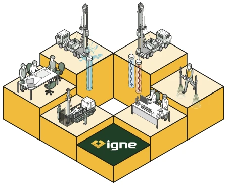
How PAS 128 Standard Utility Surveys are Designed, Planned, and Carried Out
PAS 128 standard utility surveys are carefully structured and planned to meet the specific needs of a project. At Igne, we use the latest technology and best practices to deliver high-quality results.
Here’s an overview of the process:
- Pre-Survey Planning & Desktop Research (QL-D)
The first stage of a PAS 128 survey involves gathering existing records of the utilities in the area. This is classified as a QL-D survey and typically involves obtaining plans and data from utility providers. While this provides a broad overview of the likely utility layout, it is considered the lowest confidence level since it relies on third-party data that may be incomplete or outdated. - Non-Intrusive Survey Methods (QL-C and QL-B)
Next, a non-intrusive survey is carried out using tools such as electromagnetic locators (EML) and ground-penetrating radar (GPR). These methods help detect utilities below the surface without disturbing the ground. The data gathered is classified as QL-C or QL-B, depending on the methods used and the accuracy of the results.
QL-C provides an approximate location of utilities based on site observations, while QL-B improves accuracy through geophysical techniques.
- Verification & Intrusive Methods (QL-A)
For the highest confidence level, QL-A, utilities are physically verified through excavation or vacuum excavation. This involves exposing the utility to confirm its exact location and dimensions. QL-A data provides the highest level of accuracy and is typically used when precise utility information is critical for project safety or compliance. - Data Processing & Reporting
Once the survey is complete, the data is processed and compiled into a detailed report. The report includes accurate mapping of utilities, confidence levels (QL-A to QL-D), and recommendations for any additional actions that may be required. Igne provides high-quality survey data that can be easily integrated into your project’s design and planning documents. - Ongoing Monitoring & Updates
Utility data may need to be updated during the lifecycle of a project, especially if conditions change or new utilities are installed. Igne offers ongoing monitoring and support to ensure that your project has access to the most up-to-date information, further reducing the risk of strikes or delays.
Learn More
Frequently Asked Questions about PAS 128 Standard Utility Surveys
- What is a PAS 128 standard utility survey?
A PAS 128 standard utility survey is a structured method for detecting, verifying, and mapping underground utilities, such as gas pipes, water mains, electricity cables, and telecoms infrastructure.
It follows a British standard developed by the BSI to provide consistent and accurate utility survey data.
- Why is PAS 128 important?
PAS 128 standardises the process of utility surveys, ensuring that data is collected and reported in a consistent and reliable way. This is essential for reducing the risk of utility strikes, improving project planning, and ensuring that construction projects are carried out safely and efficiently.
- What does QL-A to QL-D mean in PAS 128 surveys?
PAS 128 surveys are categorised by quality levels (QL-A to QL-D) to indicate the confidence level of the data. QL-D is the lowest confidence level and is based on desktop records, while QL-A is the highest confidence level and involves physically verifying the utility through excavation or other intrusive methods
- How long does a PAS 128 survey take?
The time it takes to complete a PAS 128 survey depends on the size and complexity of the site, as well as the quality level required. A QL-D survey (desktop research) can be completed quickly, while QL-A surveys (involving excavation) may take longer.
- How accurate is a PAS 128 standard utility survey?
The accuracy of a PAS 128 survey depends on the quality level. QL-A surveys, which involve physical verification, are the most accurate. QL-B and QL-C surveys, which use non-intrusive methods, provide good accuracy but with slightly lower confidence.
- Do I need a PAS 128 survey for my project?
If your project involves excavation, construction, or any ground disturbance, commissioning a PAS 128 utility survey is highly recommended. It helps reduce the risk of utility strikes, ensures compliance with regulations, and provides essential data for project planning and safety.
The Next Step
Ready to safeguard your project with precise and reliable utility data?
Contact Igne’s survey team today to learn more about PAS 128 standard utility surveys and explore the full range of site investigation services we offer.
Let us help you minimise risk and move your project forward with confidence.