![]()
Laser Scanning Surveys
Laser scanning technology has really transformed the surveying industry, providing unprecedented accuracy and efficiency which is of huge benefit to clients.
By using laser pulses to capture the precise points of a feature or object being scanned, laser scanners generate point cloud data, which can be applied in various sectors, including construction, transportation, heritage and building information modelling (or BIM). This list is certainly not exhaustive, but it typically frames the range of clients we support with laser scanning.
In this article we'll look at the pros, cons and applications of laser scanning - but if you require any additional information, please do contact us to discuss how we can help.
The 5 Main Benefits of Laser Scanning
1. Accuracy and Precision
Laser scanning offers such high levels of accuracy and precision, making it an invaluable service offering. We can capture minute details that traditional surveying methods may miss.
This is critical for any application requiring exact measurements.
2. Speed and Efficiency
The speed with which laser scanners can quickly capture millions of data points is unprecedented, significantly reducing the time required for fieldwork. This leads to faster project completion and ultimately, cost savings.
3. Comprehensive Data Collection
Surveyors can gather extensive data in a single session. This comprehensive capture reduces the need for multiple site visits, ensuring all necessary data is available from the initial survey. And as above in point 2, this advances programme and reduces costs.
4. Enhanced Safety
A sometimes overlooked consideration and benefit is that laser scanning allows a surveyor to collect data from a safe distance, reducing the need to physically access a hazardous or hard-to-reach area.
5. Versatility
The technology can be used in various environments, from small indoor spaces to large outdoor landscapes, making it a highly versatile tool in the surveyor's toolkit.
Are There Any Disadvantages to Laser Scanning?
1. Cost
One of the primary disadvantages is the high initial cost of purchasing laser scanning equipment and software. It requires a significant investment, particularly for smaller companies.
2. Data Overload!
The vast amount of data generated can be overwhelming. Efficient data management, processing and analysis are required to extract useful information from the point clouds.
3. A Steep Learning Curve
To effectively use the laser scanning technology requires specific training. Surveyors must become proficient in both hardware operation and data processing software.
4. Some Environmental Limitations
Factors such as weather conditions and surface reflectivity can impact the accuracy and efficiency of laser scanning. Heavy rain or fog can disrupt laser beams.
What Aare the Main Applications of Point Cloud Data?
1. Design and Architecture
Point cloud data provides architects and designers with exact dimensions of existing structures, facilitating accurate and efficient design processes. This data helps in creating detailed 3D models and blueprints.
2. Building Information Modelling (BIM)
Laser scanning integrates seamlessly with BIM, providing precise 3D representations of buildings. This enhances collaboration among stakeholders, improves project visualisation, and aids in maintenance and renovations.
3. Construction
In construction, point cloud data is used for progress monitoring, ensuring structures are built according to design specifications. It also assists in detecting deviations from the plans early, avoiding costly rework.
4. Heritage Preservation
It is invaluable in the documentation and preservation of historical sites. The laser scanning technology captures detailed records of structures, which can be used for restoration and conservation efforts.
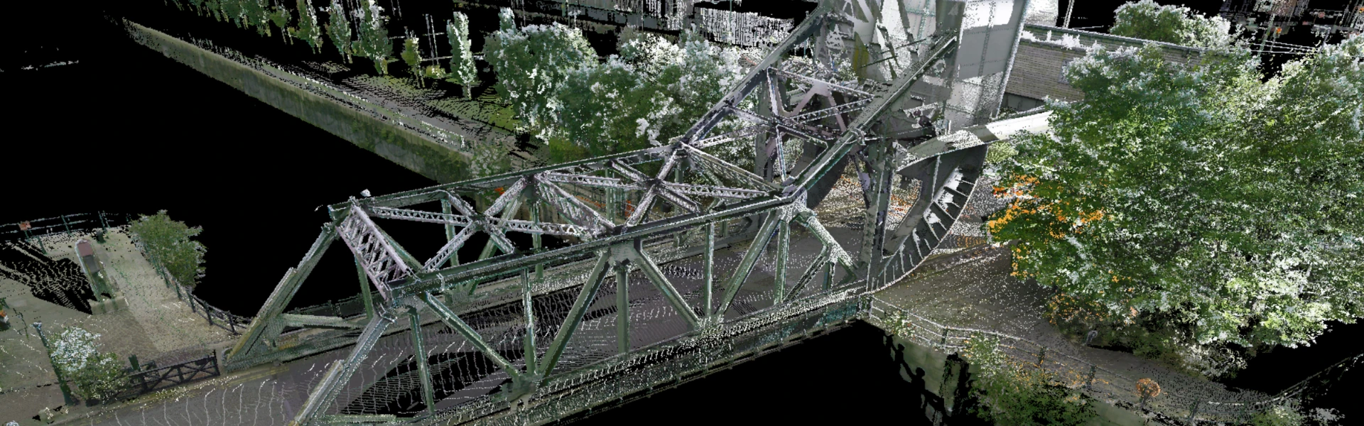
5. Infrastructure Management
For infrastructure projects like roads, bridges, and tunnels, point cloud data supports precise mapping and inspection. It helps in planning repairs and upgrades by providing accurate current conditions.
At Igne, we believe that as the technology continues to advance, its applications and efficiencies will grow, further transforming the field of surveying in which we are the highly proficient and preferred partners for our clients. They trust us to use the best equipment and methodologies to meet their exacting standards.
Put us to the test – call the team today.
Other articles of interest
Why is UXO still found in Rotherwas, Hereford?
Yesterday, a hand grenade was found in Rotherwas, Hereford. Why is unexploded ordnance (UXO) still found in Rotherwas, Hereford, over 70 years since WWII ended? Learn about Rotherwas' munitions factory, Luftwaffe bombings, and why UXO risk assessments are important for intrusive ground works.
What’s the value of UXO risk mitigation services?
What value do unexploded ordnance (UXO) risk mitigation services bring? What's the potential impact of UXO and who does it affect? Get all the answers to your frequently asked questions here.